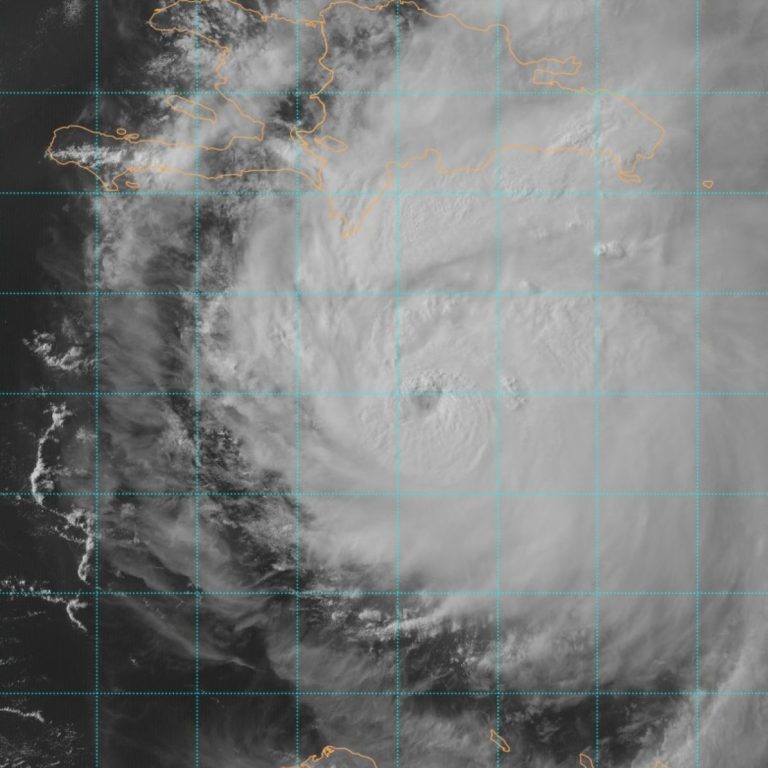
VIDEO: Hurricane Beryl Slams into the Island of Carriacou, Leaving Devastation, Threatens Jamacia
By: The Underground Meteorologist - For The Blake Moia Show -- 5pm, July 02, 2024
The Atlantic 2024 Hurricane Season is starting out with a bang. The first hurricane, which just so happens to be the season's first major one -- at Category 3 or stronger -- has made landfall on the Island of Carriacou in the Carribean and is now threatening Jamacia.
According to Levi Cowan, from TropicalTidbits.com, Hurricane Beryl has met or exceeded forecast expectations, and there's really nothing in the way in the atmosphere to stop this major hurricane from weakening. However, there is slight wind shear effecting this hurricane at this time.
VIDEO: Hurricane Beryl Makes Landfall as a Strong Category 4 Hurricane on the Island of Carriacou
The official Hurricane Center Discussion:
WHAT THE EXPERTS ARE SAYING
"SUMMARY OF 0500 PM 07/02/2024 HURRICANE BERYL FORECAST, CURRENT POSITION AND HURRICANE WARNINGS ISSUED
INFORMATION ----------------------------------------------------------------------
...EYE OF BERYL MOVING QUICKLY WEST-NORTHWESTWARD TO THE SOUTH OF HISPANIOLA... ...EXPECTED TO BRING LIFE-THREATENING WINDS AND STORM SURGE TO JAMAICA ON WEDNESDAY AND THE CAYMAN ISLANDS WEDNESDAY NIGHT AND THURSDAY...
LOCATION...15.9N 70.8W ABOUT 125 MI...205 KM SSE OF ISLA BEATA DOMINICAN REPUBLIC ABOUT
420 MI...680 KM ESE OF KINGSTON JAMAICA
MAXIMUM SUSTAINED WINDS...155 MPH...250 KM/H
PRESENT MOVEMENT...WNW OR 290 DEGREES AT 22 MPH...35 KM/H
MINIMUM CENTRAL PRESSURE...943 MB...27.85 INCHES
WATCHES AND WARNINGS --------------------
CHANGES WITH THIS ADVISORY: None.
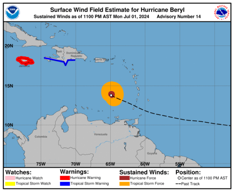
SUMMARY OF WATCHES AND WARNINGS IN EFFECT: A Hurricane Warning is in effect for...
* Jamaica * Grand Cayman * Little Cayman and Cayman Brac
A Hurricane Watch is in effect for...
* South coast of Haiti from the border with the Dominican Republic to Anse d'Hainault
A Tropical Storm Warning is in effect for... * South coast of Dominican Republic from Punta Palenque westward to the border with Haiti * South coast of Haiti from the border with the Dominican Republic to Anse d'Hainault
A Hurricane Warning means that hurricane conditions are expected somewhere within the warning area. Preparations to protect life and property should be rushed to completion.
A Tropical Storm Warning means that tropical storm conditions are expected somewhere within the warning area within 36 hours.
A Hurricane Watch means that hurricane conditions are possible within the watch area.
A watch is typically issued 48 hours before the anticipated first occurrence of tropical-storm-force winds, conditions that make outside preparations difficult or dangerous. Interests elsewhere in the northwestern Caribbean, including the Yucatan Peninsula of Mexico and Belize, should closely monitor the progress of Beryl. Additional watches or warnings will be required tonight or on Wednesday.
For storm information specific to your area, please monitor products issued by your national meteorological service.
DISCUSSION AND OUTLOOK ----------------------
At 500 PM EDT (2100 UTC), the center of Hurricane Beryl was located near latitude 15.9 North, longitude 70.8 West. Beryl is moving toward the west-northwest near 22 mph (35 km/h), and this general motion should continue through Wednesday, followed by a turn more toward the west Wednesday night or Thursday.
On the forecast track, the center of Beryl will move quickly across the central Caribbean Sea tonight and is forecast to pass near or over Jamaica on Wednesday. The center is expected to pass near or over the Cayman Islands Wednesday night or early Thursday and approach the Yucatan Peninsula of Mexico Thursday night. Maximum sustained winds are near 155 mph (250 km/h) with higher gusts.
Beryl is a category 4 hurricane on the Saffir-Simpson Hurricane Wind Scale. Weakening is forecast during the next day or two. However, Beryl is forecast to be at or near major hurricane intensity while it passes near Jamaica on Wednesday and the Cayman Islands on Wednesday night.
Additional weakening is expected thereafter, though Beryl is forecast to remain a hurricane in the northwestern Caribbean. Hurricane-force winds extend outward up to 40 miles (65 km) from the center and tropical-storm-force winds extend outward up to 185 miles (295 km). The estimated minimum central pressure is 943 mb (27.85 inches).
HAZARDS AFFECTING LAND ----------------------
Key messages for Beryl can be found in the Tropical Cyclone Discussion under AWIPS header MIATCDAT2 and WMO header WTNT42 KNHC.
WIND: Hurricane conditions are expected to reach the coast of Jamaica within the warning area on Wednesday. Winds are expected to first reach tropical storm strength early on Wednesday, making outside preparations difficult or dangerous. Hurricane conditions are expected to reach the Cayman Islands Wednesday night or early Thursday. Winds are expected to first reach tropical storm strength on Wednesday, making outside preparations difficult or dangerous. Tropical storm conditions are expected in the warning area along the south coast of Hispaniola this afternoon and tonight.
STORM SURGE: Storm surge could raise water levels by as much as 5 to 8 feet above normal tide levels in areas of onshore winds along the immediate coast of Jamaica. Storm surge could raise water levels by as much as 2 to 4 feet above normal tide levels in areas of onshore winds along the immediate coast of the Cayman Islands. Storm surge could raise water levels by as much as 1 to 3 feet above ground level in areas of onshore winds along the southern coast of Hispaniola. Near the coast, the surge will be accompanied by large and destructive waves.
RAINFALL: Hurricane Beryl is expected to produce rainfall totals of 4 to 8 inches, with localized maxima of 12 inches, across Jamaica and southwestern Haitian Peninsula through late Wednesday. Beryl will also produce rainfall amounts of 4 to 8 inches with isolated amounts of 10 inches across Barahona Peninsula in southwest Dominican Republic. Isolated totals of 6 inches or more are also anticipated across the mountainous terrain in the central Dominican Republic. This rainfall is likely to cause flash flooding and mudslides. Beryl is also expected to produce rainfall totals of 2 to 4 inches with localized maxima of 6 inches over the Cayman Islands Wednesday into Thursday.
For a complete depiction of forecast rainfall and flash flooding associated with Hurricane Beryl, please see the National Weather Service Storm Total Rainfall Graphic, available at hurricanes.gov/graphics_at2.shtml?rainqpf
SURF: Large swells generated by Beryl will continue across the Windward and southern Leeward Islands during the next day or so. Swells will impact the southern coasts of Puerto Rico and Hispaniola, and begin affecting Jamaica and the Cayman Islands through midweek. These swells are expected to cause life-threatening surf and rip current conditions.
Please consult products from your local weather office.
NEXT ADVISORY ------------- Next intermediate advisory at 800 PM EDT. Next complete advisory at 1100 PM EDT. $$ Forecaster Beven"
The National Hurricane Center issues watches and warnings for the islands.
DRAMATIC AFTERMATH
Shocking drone video captures the total destruction that left the small island in Hurricane Beryl's wake.
WHAT THE NATIONAL HURRICANE CENTER SAYS
Hurricane Beryl Discussion Number 17 July 02, 2024 5:00PM
NWS National Hurricane Center Miami FL AL022024 500 PM EDT Tue Jul 02 2024
The cloud pattern of Beryl has become a little less organized since the last reconnaissance aircraft left the storm near 17Z. While the eyewall cloud tops have cooled, the eye has become ragged and less distinct inside the central dense overcast, and the overall cloud pattern is becoming elongated due to shear.
Objective intensity estimates suggest that the hurricane has weakened a little in the past few hours, but the advisory intensity will be held at 135 kt until the arrival of the next aircraft missions near 00Z. The initial motion is a quick 290/19 kt. A strong subtropical ridge centered over the southern United States will continue to steer Beryl west-northwestward to westward across the central and northwestern Caribbean for the next few days, and this motion should bring the center near Jamaica in about 24 h, near the Cayman Islands in about 36 h, and near the Yucatan Peninsula of Mexico around 60-72 h.
After that, there remains a significant spread in the track guidance when Beryl emerges into the southwestern Gulf of Mexico, due mainly to model differences in the strength and location of a break in the subtropical ridge over the southern United States. The GFS shows a more northerly motion during this time, while the ECMWF and UKMET forecast a more westerly motion. This part of forecast track lies between these extremes near the consensus models and has a higher than normal amount of uncertainty.
The intensity forecast also continues to be uncertain. The models are in good agreement that Beryl should steadily weaken during the next 60 h due to shear and dry air entrainment, but the models show a slower rate of weakening than previously. Based on this, the new intensity forecast calls for Beryl to still be a major hurricane when it passes near Jamaica, at or near major hurricane strength when it passes the Cayman Islands, and still be a hurricane when it reaches the Yucatan Peninsula. This part of the forecast lies near the upper edge of the intensity guidance.
There remains considerable spread in the intensity guidance when Beryl emerges over the Gulf of Mexico, although there is somewhat better agreement that the cyclone will intensify some while crossing the Gulf. The new forecast follows this trend and lies near the middle of the spread-out intensity guidance.
Key Messages:
- 1. Devastating hurricane-force winds, life-threatening storm surge, and damaging waves are expected in portions of Jamaica and the Cayman Islands Wednesday and Wednesday night. Residents in these areas should listen to local government and emergency management officials for preparedness and/or evacuation orders.
- 2. Heavy rainfall and life-threatening flash flooding are likely over much of Jamaica and southern Hispaniola through late Wednesday.
- 3. Beryl is forecast to remain a hurricane when it approaches the Yucatan Peninsula and Belize late Thursday where additional watches will likely be required later today or tonight.
- 4. There remains uncertainty in the track and intensity forecast of Beryl over the western Gulf of Mexico this weekend. Interests in the southwestern and western Gulf of Mexico should monitor the progress of Beryl.
FORECAST POSITIONS AND MAX WINDS INIT
02/2100Z 15.9N 70.8W 135 KT 155 MPH 12H 03/0600Z 16.7N 73.6W 125 KT 145 MPH 24H 03/1800Z 17.7N 77.1W 110 KT 125 MPH 36H 04/0600Z 18.5N 80.6W 95 KT 110 MPH 48H 04/1800Z 19.1N 83.9W 85 KT 100 MPH 60H 05/0600Z 19.7N 87.1W 75 KT 85 MPH 72H 05/1800Z 20.7N 89.9W 55 KT 65 MPH...INLAND 96H 06/1800Z 22.5N 94.5W 60 KT 70 MPH...OVER WATER 120H 07/1800Z 24.5N 97.5W 60 KT 70 MPH $$ Forecaster Beven
PAST DISSCUSSIONS:
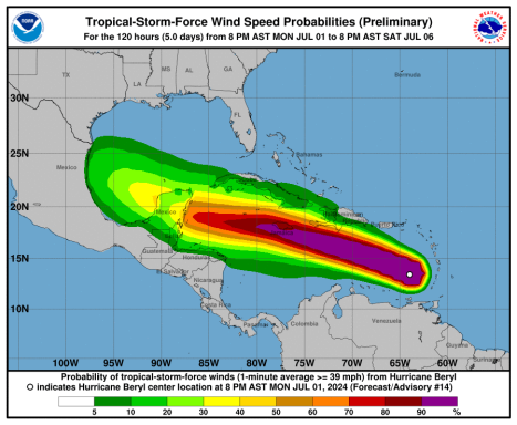
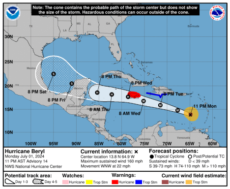
07/01/2024 11PM CURRENT HURRICANE DISSCUSION:
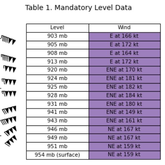
Data from a NOAA-P3 Hurricane Hunter aircraft tonight has been quite helpful in assessing Beryl's structure and intensity. Within the past hour, the aircraft measured a peak 700-mb flight-level wind of 157 kt in the northeastern quadrant. A typical 90 percent reduction translates to a maximum sustained wind of 140 kt, which makes Beryl a potentially catastrophic Category 5 hurricane.
This is the earliest Category 5 hurricane observed in the Atlantic basin on record, and only the second Category 5 hurricane to occur in July after Hurricane Emily in 2005.
Beryl continues to move quickly to the west-northwest, even a bit faster than earlier, estimated from plane fixes to be 290/19 kt. A well-established subtropical ridge oriented ESE-to-WNW of Beryl is expected to continue to steer the small but potent hurricane quickly west-northwestward into the central Caribbean over the next several days.
After 48 hours, the strongest ridging becomes positioned more NW of Beryl, and the storm could turn a bit more westward and gradually slow down when it reaches the northwestern Caribbean. The guidance this cycle has nudged a bit further north this cycle, and thus the NHC forecast track has also been shifted in that direction, roughly between the reliable HCCA and TVCN consensus aids.
After 72 hours, model track spread increases quite markedly, especially after Beryl emerges into the Gulf of Mexico, and forecast confidence in the track at the end of the forecast is rather low. While I cannot rule out a bit more intensification in the short-term, dropsonde pressure observations between fixes in Beryl's eye have remained steady at 938 mb.
It is also possible another eyewall replacement cycle (ERC) could begin like we saw last night, with UW-CIMSS MPERC model giving another ERC a 50-75 percent probability based on the last few microwave passes. With that said, after the next 24 hours, both the GFS and ECMWF remain insistent that significant mid-level westerly shear (above 30 kt) will begin to undercut Beryl's outflow layer. The HAFS-A/B regional-hurricane models, which did a good job predicting Beryl's peak intensity today, are also insistent this shear will start to disrupt the hurricane after the next 24 hours.
There is evidence of this less favorable upper-level pattern on GOES-16 water vapor imagery upwind of Beryl's track, and thus a faster rate of weakening is forecasted from 36-72 hours. There remains much uncertainty of what Beryl's structure or intensity will be as it approaches or crosses the Yucatan, but the current GFS and ECMWF upper-level pattern in the Gulf of Mexico does not look especially favorable for restrengthening at the end of the forecast period.
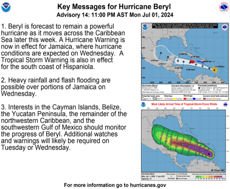
Key Messages:
1. Beryl is forecast to remain a powerful hurricane as it moves across the Caribbean Sea later this week. A Hurricane Warning is now in effect for Jamaica, where hurricane conditions are expected on Wednesday. A Tropical Storm Warning is also in effect for the south coast of Hispaniola.
2. Heavy rainfall and flash flooding are possible over portions of Jamaica on Wednesday.
3. Interests in the Cayman Islands, Belize, the Yucatan Peninsula, the remainder of the northwestern Caribbean, and the southwestern Gulf of Mexico should monitor the progress of Beryl. Additional watches and warnings will likely be required on Tuesday or Wednesday.
FORECAST POSITIONS AND MAX WINDS INIT
02/0300Z 13.8N 64.9W 140 KT 160 MPH 12H 02/1200Z 14.8N 67.7W 135 KT 155 MPH 24H 03/0000Z 15.9N 71.5W 125 KT 145 MPH 36H 03/1200Z 16.8N 75.2W 105 KT 120 MPH 48H 04/0000Z 17.7N 78.6W 95 KT 110 MPH 60H 04/1200Z 18.2N 82.2W 85 KT 100 MPH 72H 05/0000Z 18.6N 85.4W 80 KT 90 MPH 96H 06/0000Z 20.5N 91.0W 55 KT 65 MPH...OVER WATER 120H 07/0000Z 22.5N 95.0W 55 KT 65 MPH $$ Forecaster Papin
PAST ADVISORIES:
The 2am advisory: July 01, 2024
According to the National Hurricane Center, Major Hurricane Beryl is 175 miles S.E. of Barbados and 265 miles E.S.E of Grenada and is traveling W at 20 MPH with maximum sustained, wind speeds up to 120 MPH and a pressure gradient of 965 MB ...... >>>>>>>
"BULLETIN Hurricane Beryl Intermediate Advisory Number 10A NWS National Hurricane Center Miami FL
AL022024 200 AM AST Mon Jul 01 2024 ...BERYL APPROACHING THE WINDWARD ISLANDS... ...LIFE-THREATENING WINDS AND STORM SURGE EXPECTED TO BEGIN WITHIN A FEW HOURS...
WATCHES AND WARNINGS -------------------- CHANGES WITH THIS ADVISORY: None.
SUMMARY OF WATCHES AND WARNINGS IN EFFECT:
A Hurricane Warning is in effect for...
* Barbados
* St. Lucia
* St. Vincent and the Grenadine Islands
* Grenada
* Tobago
A Tropical Storm Warning is in effect for...
* Martinique
* Trinidad A Tropical Storm Watch is in effect for...
* Dominica
* South coast of Dominican Republic from Punta Palenque westward to the border with Haiti
* South coast of Haiti from the border with the Dominican Republic to Anse d'Hainault
A Hurricane Warning means that hurricane conditions are expected somewhere within the warning area. Preparations to protect life and property should be rushed to completion.
A Tropical Storm Warning means that tropical storm conditions are expected somewhere within the warning area within 36 hours.
A Tropical Storm Watch means that tropical storm conditions are possible within the watch area, generally within 48 hours. Interests elsewhere in the Lesser Antilles, Hispaniola, Jamaica, the Cayman Islands, and the remainder of the northwestern Caribbean should closely monitor the progress of Beryl.
Additional watches or warnings may be required today. For storm information specific to your area, please monitor products issued by your national meteorological service.
DISCUSSION AND OUTLOOK ----------------------
At 200 AM AST (0600 UTC), the eye of Hurricane Beryl was located near latitude 11.5 North, longitude 59.1 West. Beryl is moving toward the west near 20 mph (31 km/h). A continued quick westward to west-northwestward motion is expected during the next few days. On the forecast track, the center of Beryl is expected to move across the Windward Islands this morning and across the southeastern and central Caribbean Sea late today through Wednesday.
Maximum sustained winds are near 120 mph (195 km/h) with higher gusts. Beryl is a category 3 hurricane on the Saffir-Simpson Hurricane Wind Scale. Fluctuations in strength are likely during the next day or so, but Beryl is expected to remain a dangerous major hurricane as its core moves through the Windward Islands into the eastern Caribbean.
Hurricane-force winds extend outward up to 30 miles (45 km) from the center and tropical-storm-force winds extend outward up to 115 miles (185 km). Grantley Adams International Airport on Barbados recently reported a wind gust to 45 mph (72 km/h). The minimum central pressure based on Hurricane Hunter aircraft data is 965 mb (28.50 inches).
HAZARDS AFFECTING LAND ----------------------
Key messages for Beryl can be found in the Tropical Cyclone Discussion under AWIPS header MIATCDAT2 and WMO header WTNT42 KNHC.
WIND:
Hurricane conditions are expected in the hurricane warning area beginning early this morning. Potentially catastrophic wind damage is expected where the core of Beryl moves through portions of the Windward Islands, with the highest risk of the core in St. Vincent and the Grenadines, and Grenada. Wind speeds atop and on the windward sides of hills and mountains are often up to 30 percent stronger than the near-surface winds indicated in this advisory, and in some elevated locations could be even greater. Tropical storm conditions are expected in the tropical storm warning area starting soon, making outside preparations difficult or dangerous. Tropical storm conditions are possible within the watch area starting this morning for Dominica, and by Tuesday afternoon for parts of the southern coast of Hispaniola.
STORM SURGE:
A life-threatening storm surge will raise water levels by as much as 6 to 9 feet above normal tide levels in areas of onshore winds near where the eye makes landfall in the hurricane warning area. Near the coast, the surge will be accompanied by large and destructive waves.
RAINFALL:
Hurricane Beryl is expected to produce rainfall totals of 3 to 6 inches across Barbados and the Windward Islands through today. Localized maxima of 10 inches is possible, especially in the Grenadines. This rainfall may cause flash flooding in vulnerable areas. For a complete depiction of forecast rainfall and flash flooding associated with Hurricane Beryl, please see the National Weather Service Storm Total Rainfall Graphic, available at hurricanes.gov/graphics_at2.shtml?rainqpf SURF:
Large swells generated by Beryl are expected across Windward and southern Leeward Islands during the next couple of days. Swells are also expected to reach the southern coasts of Puerto Rico and Hispaniola in the next day or so. These swells are expected to cause life-threatening surf and rip current conditions.
Please consult products from your local weather office.
NEXT ADVISORY ------------- Next complete advisory at 500 AM AST. $$ Forecaster Blake"
---------------------------------------------------------------------------------------------------------------------------------------------------------------------------------------------
<<<<......PAST ADVISTORIES.....>>>>
The 5pm advisory: According to the National Hurricane Center, Major Hurricane Beryl is 200 miles S.E. of Barbados and 260 miles S.S.E of St. Vincent and is traveling at 10 MPH to the N.W. with wind speeds up to 130 MPH and a pressure gradient of 958 MB.
WATCHES AND WARNINGS --------------------
CHANGES WITH THIS ADVISORY:
The government of the Trinidad and Tobago has issued a Tropical Storm Warning for the island of Trinidad.
SUMMARY OF WATCHES AND WARNINGS IN EFFECT:
A Hurricane Warning is in effect for...
* Barbados
* St. Lucia
* St. Vincent and the Grenadine Islands
* Grenada
* Tobago
A Tropical Storm Warning is in effect for...
* Martinique
* Trinidad
A Tropical Storm Watch is in effect for...
* Dominica
* South coast of Dominican Republic from Punta Palenque westward to the border with Haiti
* South coast of Haiti from the border with the Dominican Republic to Anse d'Hainault
A Hurricane Warning means that hurricane conditions are expected somewhere within the warning area. Preparations to protect life and property should be rushed to completion.
A Tropical Storm Warning means that tropical storm conditions are expected somewhere within the warning area within 36 hours.
A Tropical Storm Watch means that tropical storm conditions are possible within the watch area, generally within 48 hours. Interests elsewhere in the Lesser Antilles, Hispaniola, Jamaica, the Cayman Islands, and the remainder of the northwestern Caribbean should closely monitor the progress of Beryl.
Additional watches or warnings may be required tonight or on Monday. For storm information specific to your area, please monitor products issued by your national meteorological service.
DISCUSSION AND OUTLOOK ----------------------
At 800 PM AST (0000 UTC), the center of Hurricane Beryl was located near latitude 11.2 North, longitude 57.3 West. Beryl is moving toward the west-northwest near 18 mph (30 km/h). A continued quick westward to west-northwestward motion is expected during the next few days. On the forecast track, the center of Beryl is expected to move across the Windward Islands Monday morning and across the southeastern and central Caribbean Sea late Monday through Wednesday. Data from both the Air Force Reserve and NOAA Hurricane Hunter aircraft indicate that maximum sustained winds remain near 130 mph (215 km/h) with higher gusts. Beryl is a category 4 hurricane on the Saffir-Simpson Hurricane Wind Scale. Fluctuations in strength are likely during the next day or so, and Beryl is expected to remain an extremely dangerous category 4 hurricane through landfall in the Windward Islands. Hurricane-force winds extend outward up to 30 miles (45 km) from the center and tropical-storm-force winds extend outward up to 115 miles (185 km). The minimum central pressure based on Hurricane Hunter aircraft data is 958 mb (28.29 inches).
HAZARDS AFFECTING LAND ----------------------
Key messages for Beryl can be found in the Tropical Cyclone Discussion under AWIPS header MIATCDAT2 and WMO header WTNT42 KNHC.
WIND: Hurricane conditions are expected in the hurricane warning area beginning early Monday morning. Potentially catastrophic wind damage is expected where the eyewall or core of Beryl moves through portions of the Windward Islands, with the highest risk of the core in St. Vincent and the Grenadines, and Grenada. Wind speeds atop and on the windward sides of hills and mountains are often up to 30 percent stronger than the near-surface winds indicated in this advisory, and in some elevated locations could be even greater. Tropical storm conditions are expected in the tropical storm warning area starting late tonight, making outside preparations difficult or dangerous. Tropical storm conditions are possible within the watch area starting late tonight for Dominica, and by Tuesday afternoon for parts of the southern coast of Hispaniola.
STORM SURGE: A life-threatening storm surge will raise water levels by as much as 6 to 9 feet above normal tide levels in areas of onshore winds near where the eye makes landfall in the hurricane warning area. Near the coast, the surge will be accompanied by large and destructive waves.
RAINFALL: Hurricane Beryl is expected to produce rainfall totals of 3 to 6 inches across Barbados and the Windward Islands through Monday. Localized maxima of 10 inches is possible, especially in the Grenadines. This rainfall may cause flash flooding in vulnerable areas. For a complete depiction of forecast rainfall and flash flooding associated with Hurricane Beryl, please see the National Weather Service Storm Total Rainfall Graphic, available at hurricanes.gov/graphics_at2.shtml?rainqpf
SURF: Large swells generated by Beryl are expected across Windward and southern Leeward Islands during the next couple of days. Swells are also expected to reach the southern coasts of Puerto Rico and Hispaniola in the next day or so. These swells are expected to cause life-threatening surf and rip current conditions. Please consult products from your local weather office.
©Copyright 2024. All rights reserved. The Blake Moia Show. Privacy Policy
We need your consent to load the translations
We use a third-party service to translate the website content that may collect data about your activity. Please review the details in the privacy policy and accept the service to view the translations.
