Tropical Storm Milton Forms and is Headed to Florida. We Urge Everyone to Pay Attention and Prepare.
Oct. 5th, 2024 -- 4am: By: The Underground Meteorologist -- The Blake Moia Show
UPDATED: Oct. 5th, 2:30pm
Potential Hurricane in the Makings
MELBOURNE, FLORIDA --
The National Hurricane Center (NHC) and local meteorologists are urging everyone to pay attention to the forecasts this weekend.
Meteorologists and computer models indicate that all eyes should be on the Tampa Bay, Central and South Florida area. Models are predicting upwards to a foot of rainfall in the Brevard County area next week.
An area of low-pressure in the Western Gulf of Mexico has formed into a tropical storm, according to the NHC. That area low-pressure will eventually form into a hurricane and get caught up with the steering currents where are going east, towards Florida.
Interests and residences in the Florida peninsula should take action to prepare for the storm.
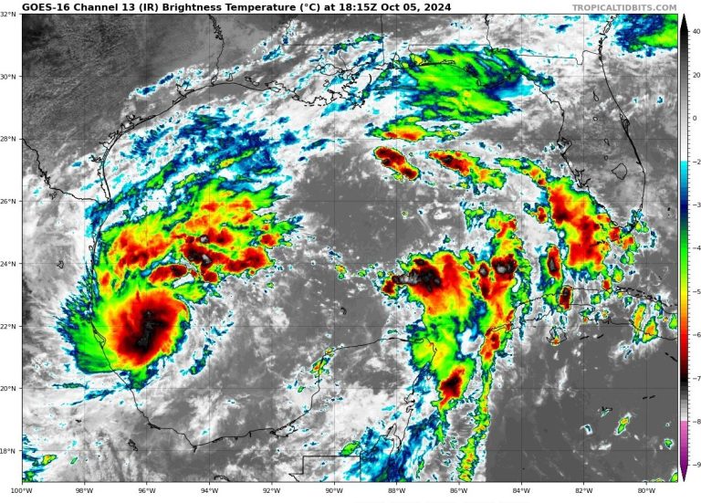
Current IR Image
Early morning one-minute GOES-East satellite imagery shows that the circulation associated with the area of low pressure over the southwestern Gulf of Mexico has become better defined.
Deep convection has been persistent over the northwestern portion of the circulation with some increase in banding also noted. Based on the recent increase in organization, advisories are being initiated on Tropical Depression Fourteen.
The initial intensity is set at 30 kt which is supported by overnight ASCAT data. Another ASCAT pass is expected over the system later this morning.
Video Courtesy of TropicalTidbits.com
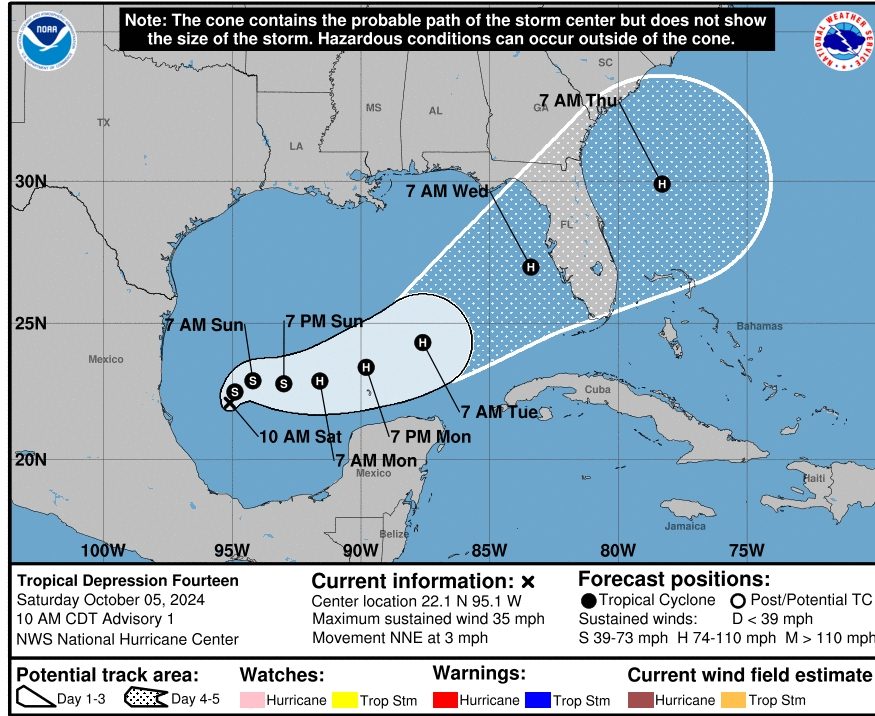
The depression is moving north-northeastward or 025/3 kt. The system is forecast to drift northeastward or east-northeastward during the next day or so.
After that time, a trough moving southward over the northwestern Gulf of Mexico is expected to cause the system to turn east-northeastward to northeastward at a slightly faster forward speed.
By Tuesday the cyclone is expected to move northeastward at an increasingly faster forward speed and this track will bring the system across the west coast of the Florida Peninsula by midweek. The track guidance is in good agreement on this overall scenario, but there are differences in the forward speed.
The NHC track lies near the various consensus aids, but it slightly faster since the typically reliable GFS and ECMWF global models are on the faster side of the guidance. Users are reminded to not focus on the exact forecast track or timing at the longer range as the average NHC 4-day track error is about 150 miles.
What The National Hurricane Center Says
The depression is within a favorable environment of low vertical wind shear and warm sea surface temperatures. These conditions are expected to allow for steady to rapid strengthening over the next few days.
The intensification is likely to be slower during the next 12 to 24 hours until an inner core can become established, but after that time a faster rate of strengthening is anticipated. The global models predicted significant deepening when the system moves across the central and eastern Gulf of Mexico and the regional hurricane models show the potential for rapid strengthening during that time. The NHC forecast follows suit and calls for a period of rapid intensification after 36 h.
The official forecast shows the system nearing major hurricane strength over the central and eastern Gulf of Mexico. This forecast is near the intensity consensus aids but some upward adjustment may be required as it lies a little below the regional hurricane models. Regardless of the exact details of the intensity forecast, an intense hurricane with multiple life-threatening hazards is likely to affect the west coast of the Florida Peninsula next week.
Key Messages:
- 1. The depression is forecast to quickly intensify while it moves eastward to northeastward across the Gulf of Mexico and be at or near major hurricane strength when it reaches the west coast of the Florida Peninsula mid-week.
- 2. There is an increasing risk of life-threatening storm surge and wind impacts for portions of the west coast of the Florida Peninsula beginning late Tuesday or Wednesday. Residents in these areas should ensure they have their hurricane plan in place, follow any advice given by local officials, and check back for updates to the forecast.
- 3. Areas of heavy rainfall will impact portions of Florida Sunday and Monday well ahead of the tropical system, with heavy rainfall more directly related to the system expected by later Tuesday through Wednesday. This rainfall brings the risk of flash, urban, and areal flooding, along with minor to isolated moderate river flooding.
FROM THE BLAKE MOIA SHOW ARCHIVES
©Copyright 2024. All rights reserved. The Blake Moia Show. Privacy Policy
We need your consent to load the translations
We use a third-party service to translate the website content that may collect data about your activity. Please review the details in the privacy policy and accept the service to view the translations.


