Tropical Cyclone Number 1 Forms
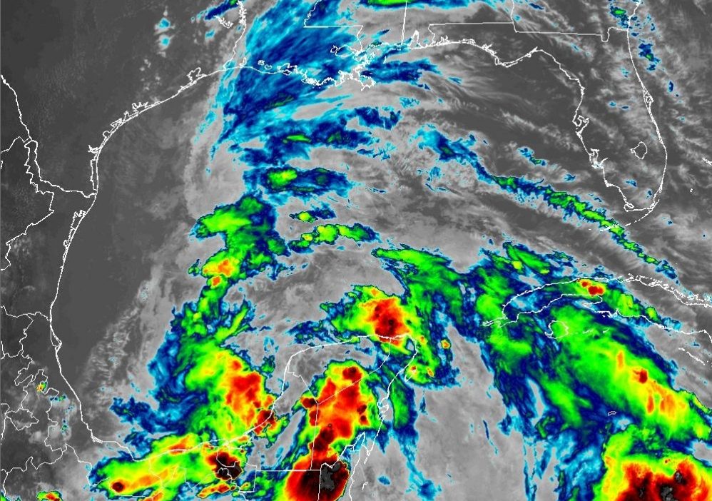
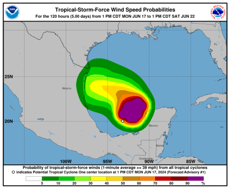
A tropical cyclone is forming in the bay of Campeche in the lower-Western Gulf of Mexico. Tropical storm and flood watches and warnings have been issued for Eastern Mexico and Texas.
The Latest Watches, Warnings and Advisories:
TROPICAL STORM WATCH:
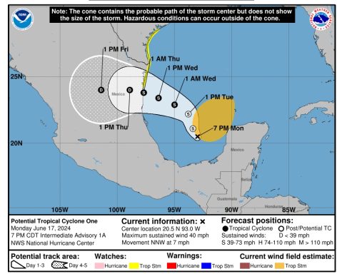
A Tropical Storm Watch has been issued for the Texas coast from Port O'Connor southward to the mouth of the Rio Grande.
THE GOVERNMENT OF MEXICO:
The government of Mexico has issued a Tropical Storm Watch for the northeastern coast of Mexico south of the mouth of the Rio Grande to Boca de Catan.
FLASH FLOODING / LANDSLIDES:
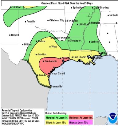
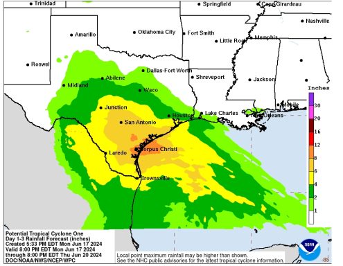
Rainfall totals of 5 to 10 inches across northeast Mexico into South Texas, with maximum totals of 15 inches possible.
This rainfall will likely produce flash and urban flooding along with new and renewed river flooding. Mudslides are also possible in areas of higher terrain across northeast Mexico.
STORM SURGE:
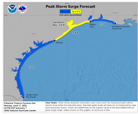
The combination of a dangerous storm surge and the high tide will cause normally dry areas near the coast to be flooded by rising waters moving inland from the shoreline.
The National Hurricane Center in Miami, Florida issued the following predictions.
The Complete Forecast:
Potential Tropical Cyclone One Discussion Number 1
NWS National Hurricane Center Miami FL
AL012024 400 PM CDT Mon Jun 17 2024
Satellite, surface, and aircraft data show that the center of the large low-pressure area is over the Bay of Campeche with a central pressure near 1001 mb. The system currently does not have the structure of a tropical cyclone just yet, as the associated convection is poorly organized, and the maximum winds are located about 200-250 n mi northeast of the center.
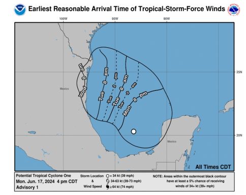
The various global models forecast this band of stronger winds to start moving onto the western Gulf coast on Wednesday, and a Tropical Storm Watch is required at this time. Thus, advisories are being initiated on Potential Tropical Cyclone One. The initial motion is 345/6.
This general motion should continue for the next 24 hours or so, although there could be some erratic motion due to center reformation. After that, the cyclone is expected to turn west-northwestward and westward on the south side of a mid- to upper-level ridge over the northern Gulf coast.
This should steer the system into northeastern Mexico between 48-72 hours.
While there are differences in details due to the disorganized nature of the system, the track guidance is in good agreement on this general scenario. The global models suggest that some deepening of the central pressure could occur, although none of them currently forecast the system to tighten up into a classic tropical cyclone.
Based on that, the intensity forecast calls for only modest strengthening. There is a chance than a small-scale vorticity center inside the large cyclonic envelope may develop enough convection to form a tighter wind core as suggested by the GFS, and based on this possibility the forecast has the system becoming a tropical storm in about 36 hours. However, there is a chance the system will never become a tropical cyclone.
Key Messages:
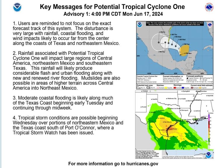
- 1. Users are reminded to not focus on the exact forecast track of this system. The disturbance is very large with rainfall, coastal flooding, and wind impacts likely to occur far from the center along the coasts of Texas and northeastern Mexico.
- 2. Rainfall associated with Potential Tropical Cyclone One will impact large regions of Central America, northeastern Mexico and southeastern Texas. This rainfall will likely produce considerable flash and urban flooding along with new and renewed river flooding. Mudslides are also possible in areas of higher terrain across Central America into Northeast Mexico.
- 3. Moderate coastal flooding is likely along much of the Texas Coast beginning early Tuesday and continuing through midweek.
- 4. Tropical storm conditions are possible beginning Wednesday over portions of northeastern Mexico and the Texas coast south of Port O’Connor, where a Tropical Storm Watch has been issued.
NOTICE...
LAND-BASED TROPICAL CYCLONE WATCHES AND WARNINGS ARE NO LONGER INCLUDED IN THE TROPICAL CYCLONE FORECAST/ADVISORY...(TCM).
CURRENT LAND-BASED COASTAL WATCHES AND WARNINGS CAN BE FOUND IN THE MOST RECENTLY ISSUED TROPICAL CYCLONE PUBLIC ADVISORY...(TCP).
POTENTIAL TROP CYCLONE CENTER LOCATED NEAR 20.3N 93.2W AT 17/2100Z POSITION ACCURATE WITHIN 40 NM PRESENT MOVEMENT TOWARD THE NORTH-NORTHWEST OR 345 DEGREES AT 6 KT ESTIMATED MINIMUM CENTRAL PRESSURE 1001 MB MAX SUSTAINED WINDS 35 KT WITH GUSTS TO 45 KT. 34 KT.......250NE 0SE 0SW 0NW. WINDS AND SEAS VARY GREATLY IN EACH QUADRANT. RADII IN NAUTICAL MILES ARE THE LARGEST RADII EXPECTED ANYWHERE IN THAT QUADRANT. REPEAT...CENTER LOCATED NEAR 20.3N 93.2W
AT 17/2100Z AT 17/1800Z CENTER WAS LOCATED NEAR 20.0N 93.2W FORECAST VALID 18/0600Z 21.1N 93.4W...
POTENTIAL TROP CYCLONE MAX WIND 35 KT...GUSTS 45 KT. 34 KT...250NE 0SE 0SW 0NW.
FORECAST VALID 18/1800Z 22.2N 93.8W.
POTENTIAL TROP CYCLONE MAX WIND 35 KT...GUSTS 45 KT. 34 KT...250NE 0SE 0SW 0NW. FORECAST VALID 19/0600Z 22.9N 95.0W...TROPICAL CYCLONE MAX WIND 35 KT...GUSTS 45 KT. 34 KT...250NE 0SE 0SW 0NW. FORECAST VALID 19/1800Z 23.4N 96.4W...TROPICAL CYCLONE MAX WIND 40 KT...GUSTS 50 KT. 34 KT...250NE 0SE 0SW 0NW. FORECAST VALID 20/0600Z 23.8N 97.7W...TROPICAL CYCLONE MAX WIND 40 KT...GUSTS 50 KT. 34 KT...250NE 0SE 0SW 0NW. FORECAST VALID 20/1800Z 24.0N 98.9W...
INLAND MAX WIND 30 KT...GUSTS 40 KT.
EXTENDED OUTLOOK.
NOTE...ERRORS FOR TRACK HAVE AVERAGED NEAR 125 NM ON DAY 4 AND 175 NM ON DAY 5...AND FOR INTENSITY NEAR 15 KT EACH DAY OUTLOOK VALID 21/1800Z 24.0N 101.4W...INLAND MAX WIND 20 KT...GUSTS 30 KT.
OUTLOOK VALID 22/1800Z...
DISSIPATED REQUEST FOR 3 HOURLY SHIP REPORTS WITHIN 300 MILES OF 20.3N 93.2W INTERMEDIATE PUBLIC ADVISORY...WTNT31 KNHC/MIATCPAT1...AT 18/0000Z
©Copyright 2024. All rights reserved. The Blake Moia Show. Privacy Policy
We need your consent to load the translations
We use a third-party service to translate the website content that may collect data about your activity. Please review the details in the privacy policy and accept the service to view the translations.
