Florida Under State of Emergency Ahead of Hurricane Helen's Arrival
Sept. 25. 2024 -- 11pm: The Underground Meteorologist -- The Blake Moia Show Weather Report
ALL of Florida Under Tropical Storm Warning
According to the National Hurricane Center Public Advisory, as of Sept. 25, 2024, 11pm est.
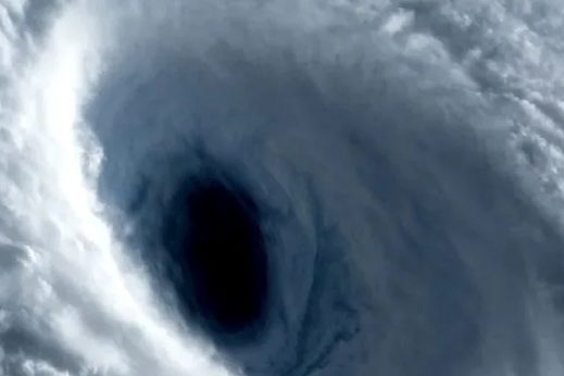
Satellite images show that Helene has a well-organized appearance,
with numerous convective banding features. A ragged-looking eye
feature is also apparent. However, reports from both Air Force and
a NOAA Hurricane Hunter aircraft investigating the system suggest
that the it lacks a well-defined inner core with a somewhat broad
maximum wind field for now. The central pressure has dropped a
little to around 972 mb.
Given the slowly falling central pressure, the intensity is maintained at 75 kt for this advisory.
Helene's structure and intensity will continue to be closely monitored by Hurricane Hunter aircraft tonight and Thursday. The hurricane continues moving northward with an estimated initial motion of 360/08 kt. For the next couple of days, the steering scenario for this system remains basically unchanged from the earlier advisory.
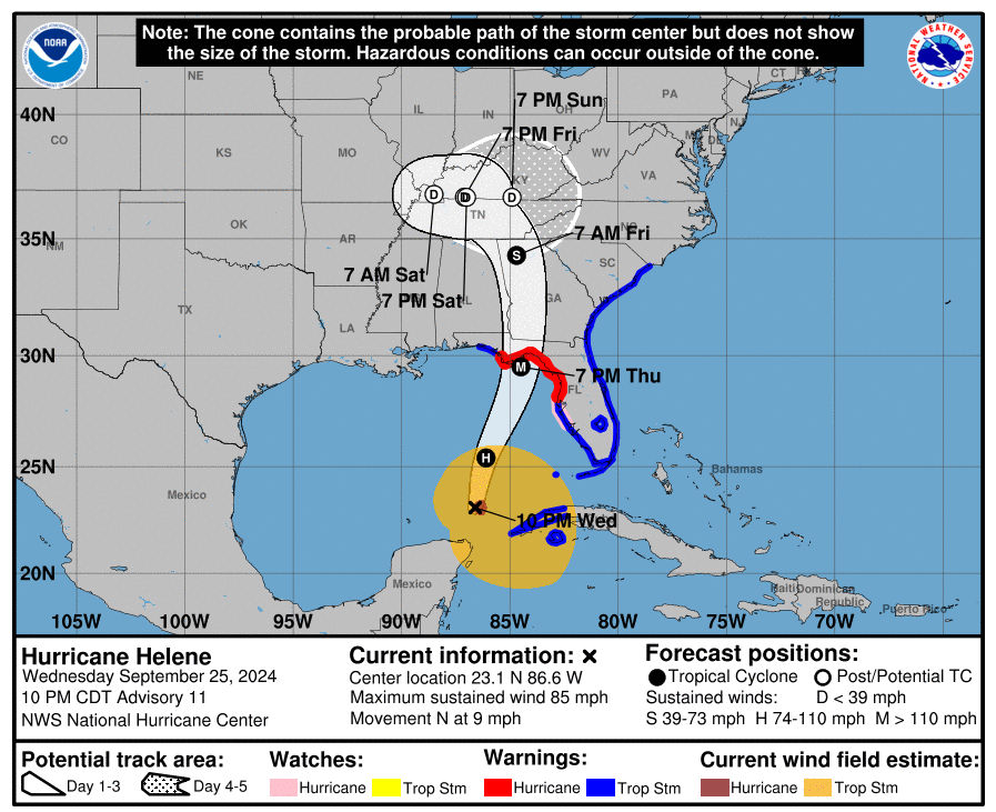
The flow between a mid-tropospheric trough over the east-central United States and a ridge over the western Atlantic should result in Helene accelerating northward to north-northeastward during the next 24 to 36 hours. This motion will bring the center of Helene to the northeastern Gulf of Mexico coast in about 24 hours.
The official track forecast through landfall is very similar to the previous NHC prediction and remains close to the corrected consensus guidance. After landfall, the trough to the northwest of the tropical cyclone becomes a cutoff low, and Helene should turn leftward as it rotates around the low. In 3-4 days, the system should become a shallow extratropical cyclone within weaker steering currents. Helene should be in an atmospheric and oceanic environment over the eastern Gulf of Mexico that will be very conducive for strengthening.
The system is expected to traverse the Loop Current, which has especially high oceanic heat content. This, along with fairly low vertical wind shear and a moist mid- to lower- tropospheric air mass, should likely result in rapid intensification before landfall.
The official forecast continues to call for the hurricane to reach category 4 status tomorrow. It should be noted that the HAFS-A and HAFS-B regional hurricane models show even more intensification than indicated here. Helene is forecast to be a large major hurricane when it reaches the Big Bend coast of Florida.
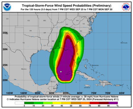
As a result, storm surge, wind, and rainfall impacts will extend well away from the center and outside the forecast cone, particularly on the east side. In addition, the fast forward speed when Helene moves inland will result in a far inland penetration of strong winds over parts of the southeastern United States, including strong gusts over higher terrain of the southern Appalachians. A higher-than-normal gust factor is indicated in the official forecast while Helene is inland.
KEY MESSAGES:
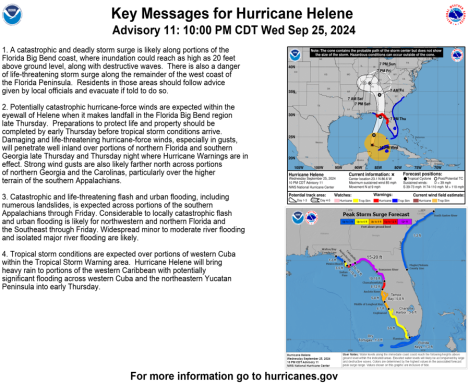
- 1. A catastrophic and deadly storm surge is likely along portions of the Florida Big Bend coast, where inundation could reach as high as 20 feet above ground level, along with destructive waves. There is also a danger of life-threatening storm surge along the remainder of the west coast of the Florida Peninsula. Residents in those areas should follow advice given by local officials and evacuate if told to do so.
- 2. Potentially catastrophic hurricane-force winds are expected within the eyewall of Helene when it makes landfall in the Florida Big Bend region late Thursday. Preparations to protect life and property should be completed by early Thursday before tropical storm conditions arrive. Damaging and life-threatening hurricane-force winds, especially in gusts, will penetrate well inland over portions of northern Florida and southern Georgia late Thursday and Thursday night where Hurricane Warnings are in effect. Strong wind gusts are also likely farther north across portions of northern Georgia and the Carolinas, particularly over the higher terrain of the southern Appalachians.
- 3. Catastrophic and life-threatening flash and urban flooding, including numerous landslides, is expected across portions of the southern Appalachians through Friday. Considerable to locally catastrophic flash and urban flooding is likely for northwestern and northern Florida and the Southeast through Friday. Widespread minor to moderate river flooding and isolated major river flooding are likely.
- 4. Tropical storm conditions are expected over portions of western Cuba within the Tropical Storm Warning area. Hurricane Helene will bring heavy rain to portions of the western Caribbean with potentially significant flooding across western Cuba and the northeastern Yucatan Peninsula into early Thursday.
The Hazards
...HELENE EXPECTED TO BRING CATASTROPHIC WINDS AND STORM SURGES TO THE NORTHEASTERN GULF COAST... ...PREPARATIONS TO PROTECT LIFE AND PROPERTY SHOULD BE RUSHED TO COMPLETION...
SUMMARY OF 1000 PM CDT...0300 UTC...
INFORMATION -----------------------------------------------
LOCATION...23.1N 86.6W ABOUT 425 MI...680 KM SW OF TAMPA FLORIDA ABOUT 465 MI...750 KM SSW OF APALACHICOLA FLORIDA MAXIMUM SUSTAINED WINDS...85 MPH...140 KM/H PRESENT MOVEMENT...N OR 360 DEGREES AT 9 MPH...15 KM/H MINIMUM CENTRAL PRESSURE...972 MB...28.71 INCHES
WATCHES AND WARNINGS --------------------
CHANGES WITH THIS ADVISORY:
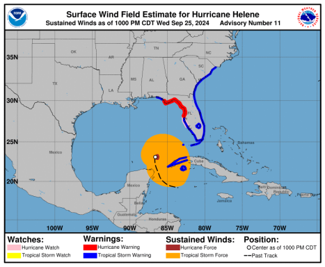
The government of Mexico has discontinued the Hurricane and Tropical Storm Warnings for the Yucatan Peninsula of Mexico. The government of Cuba has discontinued the Hurricane Watch for the Cuban province of Pinar del Rio.
SUMMARY OF WATCHES AND WARNINGS IN EFFECT:
A Storm Surge Warning is in effect for...
- * Mexico Beach eastward and southward to Flamingo
- * Tampa Bay
- * Charlotte Harbor
A Hurricane Warning is in effect for...
- * Anclote River to Mexico Beach
A Hurricane Watch is in effect for...
- * Englewood to Anclote River, including Tampa Bay
A Tropical Storm Warning is in effect for...
* Florida Keys, including the Dry Tortugas * Flamingo to Anclote River, including Tampa Bay * West of Mexico Beach to the Okaloosa/Walton County Line * Flamingo northward to Little River Inlet * Lake Okeechobee * Cuban provinces of Artemisa, Pinar del Rio, and the Isle of Youth, and ALL of Florida.
A Storm Surge Warning means there is a danger of life-threatening inundation, from rising water moving inland from the coastline, during the next 36 hours in the indicated locations.
*****This is a life-threatening situation.*****
Persons located within these areas should take all necessary actions to protect life and property from rising water and the potential for other dangerous conditions.
Promptly follow evacuation and other instructions from local officials. A Hurricane Warning means that hurricane conditions are expected somewhere within the warning area.
A warning is typically issued 36 hours before the anticipated first occurrence of tropical-storm-force winds, conditions that make outside preparations difficult or dangerous.
Preparations to protect life and property should be rushed to completion.
A Tropical Storm Warning means that tropical storm conditions are expected somewhere within the warning area within the next 36 hours.
A Storm Surge Watch means there is a possibility of life- threatening inundation, from rising water moving inland from the coastline, in the indicated locations during the next 48 hours.
A Hurricane Watch means that hurricane conditions are possible within the watch area.
A watch is typically issued 48 hours before the anticipated first occurrence of tropical-storm-force winds, conditions that make outside preparations difficult or dangerous.
For storm information specific to your area in the United States, including possible inland watches and warnings, please monitor products issued by your local National Weather Service forecast office.
For storm information specific to your area outside of the United States, please monitor products issued by your national meteorological service.
DISCUSSION AND OUTLOOK ---------------------- At 1000 PM CDT (0300 UTC), the center of Hurricane Helene was located near latitude 23.1 North, longitude 86.6 West.
Helene is moving toward the north near 9 mph (15 km/h). A northward or north-northeastward motion at a faster forward speed is expected during the next 36 hours.
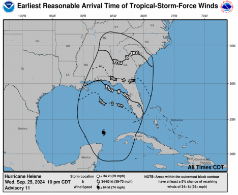
On the forecast track, Helene will move across the eastern Gulf of Mexico tonight and Thursday and cross the Florida Big Bend coast Thursday evening. After landfall, Helene is expected to turn northwestward and slow down over the Tennessee Valley on Friday and Saturday. Maximum sustained winds are near 85 mph (140 km/h) with higher gusts.
Strengthening is forecasted, and Helene is expected to be a major hurricane when it reaches the Florida Big Bend coast Thursday evening.
Weakening is expected after landfall, but Helene's fast forward speed will allow strong, damaging winds, especially in gusts, to penetrate well inland across the southeastern United States, including over the higher terrain of the southern Appalachians. Hurricane-force winds extend outward up to 35 miles (55 km) from the center and tropical-storm-force winds extend outward up to 345 miles (555 km). The minimum central pressure reported by Hurricane Hunter aircraft is 972 mb (28.71 inches).
HAZARDS AFFECTING LAND ----------------------
STORM SURGE: The combination of a life-threatening storm surge and the tide will cause normally dry areas near the coast to be flooded by rising waters moving inland from the shoreline.
The water could reach the following heights above ground somewhere in the indicated areas if the peak surge occurs at the time of high tide...
- Carrabelle, FL to Suwannee River, FL...15-20 ft
- Apalachicola, FL to Carrabelle, FL...10-15 ft
- Suwannee River, FL to Chassahowitzka, FL...10-15 ft
- Chassahowitzka, FL to Anclote River, FL...8-12 ft
- Indian Pass, FL to Apalachicola, FL...6-10 ft
- Anclote River, FL to Middle of Longboat Key, FL...5-8 ft
- Tampa Bay...5-8 ft Middle of Longboat Key, FL to Englewood, FL...4-7 ft
- East of Mexico Beach, FL to Indian Pass, FL...3-5 ft
- Englewood, FL to Flamingo, FL...3-5 ft
- Charlotte Harbor...3-5 ft
Surge. Storm surge could raise water levels by as much as 2 to 4 feet above normal tide levels in areas of onshore winds along the southern coast of Pinar del Rio, Cuba, including the Isle of Youth.
Storm surge could raise water levels by as much as 3 to 5 feet above ground level in areas of onshore winds within the warning area along the north coast of the Yucatan Peninsula.
WIND: Hurricane conditions are expected within the U.S. hurricane warning area late Thursday, with tropical storm conditions beginning Thursday morning. Tropical storm conditions are expected in southern Florida tonight and will spread northward across the rest of Florida, Georgia, and South Carolina through Thursday night.
Tropical storm conditions are expected over portions of the warning area in western Cuba during the next several hours.
RAINFALL: Hurricane Helene is expected to produce total rain accumulations of 4 to 8 inches over western Cuba, the Cayman Islands and the northeast Yucatan Peninsula, with isolated totals around 12 inches.
This rainfall brings a risk of considerable flooding. Over portions of the Southeastern U.S. into the Southern Appalachians, Helene is expected to produce total rain accumulations of 6 to 12 inches with isolated totals around 18 inches. This rainfall will likely result in catastrophic and potentially life-threatening flash and urban flooding, along with significant river flooding.
Numerous landslides are expected in steep terrain across the southern Appalachians.
TORNADOES: A tornado or two may occur tonight over parts of Florida. The risk for tornadoes will increase on Thursday, expanding northward across Florida into parts of Georgia and South Carolina.
SURF: Swells generated by Helene will affect the southern coast of Cuba and the Yucatan Peninsula of Mexico during the next couple of days. Swells will spread northward toward the west coast of Florida and the northeastern Gulf Coast tonight and Thursday. These swells are likely to cause life-threatening surf and rip current conditions. Please consult products from your local weather office.
Graphics Provided by The National Hurricane Center
Florida Counties Under State of Emergency
Florida Govenor Ron Desantis has issued a State of Emergency for all Florida Counties ahead of the hurricane. In a release, Govenor Desantis says, "we already have nearly 18,000 linemen staged (and more en route), and are ready with search and rescue and roadway clearing crews."
Brevard County is in the list of Counties under a State of Emergency.
Alachua, Baker, Bay, Bradford, Brevard, Calhoun, Charlotte, Citrus, Clay, Collier, Columbia, DeSoto, Dixie, Duval, Escambia, Flagler, Franklin, Gadsden, Gilchrist, Glades, Gulf, Hamilton, Hardee, Hendry, Hernando, Highlands, Hillsborough, Holmes, Jackson, Jefferson, Lafayette, Lake, Lee, Leon, Levy, Liberty, Madison, Manatee, Marion, Monroe, Nassau, Okaloosa, Okeechobee, Orange, Osceola, Pasco, Pinellas, Polk, Putnam, Santa Rosa, Sarasota, Seminole, St. Johns, Sumter, Suwannee, Taylor, Union, Volusia, Wakulla, Walton, and Washington counties.
With one signature, Govenor DeSantis did the following:
- He designated a State Coordinating Officer and gave that person emergency powers
- He invoked agreements between Florida and other states to coordinate resources
- He asked for federal help if needed
- He directed state, regional and governmental agencies to identify and provide personnel to help, including law enforcement
- He suspended any state statute, rule or order that would prevent or delay any emergency response, and permitted local governments to do the same
- He ordered the Florida National Guard, and the Florida State Guard activated
- He temporarily suspended all the rules regarding state agency budgets, purchasing, travel, and employment and employment compensation as needed to deal with the emergency
- He permitted local governments to enter into contracts, incur obligations, hire workers, use volunteers, rent equipment, acquire and distribute supplies, materials and facilities (with or without compensation)
The declaration also empowered the Secretary of the Department of Transportation to essentially do whatever was necessary to make evacuation routes and response access available, allowed pharmacists to dispense up to a 30-day emergency prescription refill, authorized the use of public facilities for shelters, allowed medical professionals and workers licensed outside Florida to help here, emphasized just how illegal price gouging goods and services during an emergency is, and more.
FROM THE BLAKE MOIA SHOW ARCHIVES
©Copyright 2024. All rights reserved. The Blake Moia Show. Privacy Policy
We need your consent to load the translations
We use a third-party service to translate the website content that may collect data about your activity. Please review the details in the privacy policy and accept the service to view the translations.
