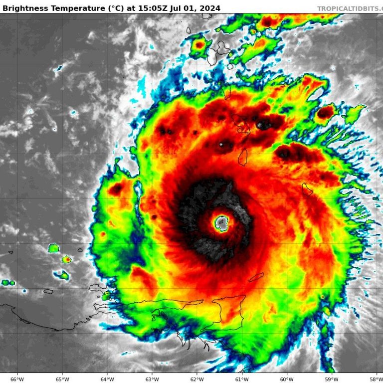
The First Hurricane of The Season is Here -- and It's a Major Cat. 4 Hurricane. What to Know.
By: The Underground Meteorologist - For The Blake Moia Show -- 10:00pm, June 30, 2024
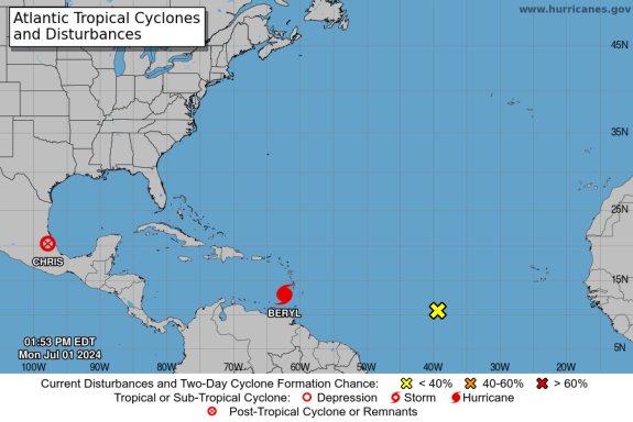
The Atlantic 2024 Hurricane Season is starting out with a bang. The first hurricane, which just so happens to be the season's first major one -- at Category 3 or stronger -- has formed in the main development region of the Tropical Atlantic and is now a Category 4 Hurricane.
According to Levi Cowan, from TropicalTidbits.com, Hurricane Beryl has met or exceeded forecast expectations, and there's really nothing in the way in the atmosphere to stop this major hurricane from weakening. The trade winds at the middle levels of the atmosphere are strong and are pulling the life-threatening hurricane to the West-Northwest, Cowan said.
The official Hurricane Center Discussion:
WHAT THE EXPERTS ARE SAYING
Hurricane Beryl Discussion Number 10...Corrected
NWS National Hurricane Center Miami FL
AL022024 2AM EST
Sun Jun 30, 2024 Corrected location of Beryl in the final paragraph.
There are a few pieces of evidence that show that Beryl is in the middle of an eyewall replacement cycle (ERC). The clear eye seen on infrared satellite earlier today has become a little more clouded over during the past few hours. In addition, data from the last leg through Beryl from both the Air Force Reserve and NOAA Hurricane Hunters indicated concentric eyewalls, which also matches current radar imagery we are receiving from Barbados Meteorological Service. An earlier SSMIS microwave pass at 2150 UTC also showed a formative outer moat forming outside the small inner eyewall. In response to the evolving structure, 700-mb flight-level winds from the NOAA and Air Force planes are a little lower than observed earlier today, and the latest round of Dvorak estimates also support a slightly lower intensity. However, the initial intensity will remain at 115 kt for this advisory, given a couple of dropsonde observations in the NE quadrant of Beryl's inner eyewall.
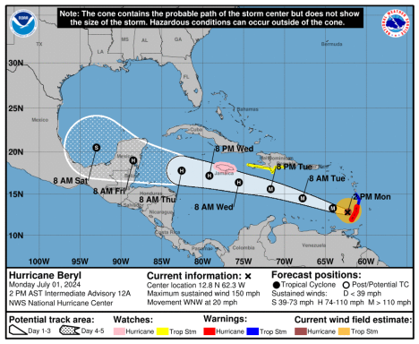
Aircraft fixes indicate Beryl continues to move quickly westward at 280/17 kt. There isn't much change with the track forecast philosophy, as a extensive mid-level ridge poleward of Beryl should maintain its westward to west-northwest motion for the next few days as it move through the Windward Islands and into the eastern Caribbean Sea. The ridge does become positioned more northwest of Beryl towards the end of the forecast period, potentially allowing the hurricane to slow down gradually once it reaches the northwestern Caribbean Sea. The track guidance this cycle is quite similar to the previous cycle, and thus the latest NHC track forecast is also quite similar to the prior advisory. Given the evolution to Beryl's inner core structure tonight due to the aforementioned ERC, it would not be surprising to see a short-term fluctuation down in Beryl's peak winds, though Beryl is expected to remain a dangerous major hurricane as it crosses through the Windward Islands tomorrow morning. In fact, there could also be a bit of restrengthening after the ERC completes in the eastern Caribbean, and that is reflected in the short-term forecast. After 48 hours, a subtle upper-level trough to Beryl's north could induce a bit more westerly vertical wind shear over the hurricane, and some gradual weakening continues to be shown after 48 hours. However, it should be emphasized that Beryl is forecast to remain a significant hurricane during its entire trek across the Caribbean region, though more prominent weakening is likely if Beryl crosses the Yucatan between days 4-5 as shown in the latest forecast.
The NHC intensity forecast remains in good agreement with the consensus aids, and is only slightly adjusted from the prior advisory.
Key Messages:
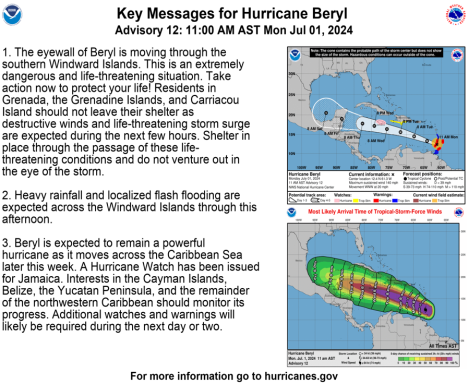
- 1. Beryl is expected to remain an extremely dangerous major hurricane when it reaches the Windward Islands tomorrow morning. This is a very dangerous situation and residents in these areas should listen to local government and emergency management officials for any preparedness and/or evacuation orders. These preparations should have been completed today as significant impacts will begin tomorrow morning.
- 2. Potentially catastrophic hurricane-force winds, a life- threatening storm surge, and damaging waves are expected when Beryl passes over portions of the Windward Islands with the highest risk of the core in St. Vincent and the Grenadines, and Grenada beginning early Monday morning. Hurricane Warnings are in effect for much of the Windward Islands.
- 3. Heavy rainfall and localized flooding are expected across the Windward Islands through Monday.
- 4. Beryl is expected to remain a powerful hurricane as it moves across the Caribbean Sea later this week. A Tropical Storm Watch is in effect for portions of the southern coast of the Dominican Republic and Haiti. Interests elsewhere in Hispaniola, Jamaica, the Cayman Islands, and the remainder of the northwestern Caribbean should monitor its progress and additional Watches and Warnings will likely be required this week.
The National Hurricane Center issues watches and warnings for the islands.
WHAT THE NATIONAL HURRICANE CENTER SAYS
The 2am advisory: July 01, 2024
According to the National Hurricane Center, Major Hurricane Beryl is 175 miles S.E. of Barbados and 265 miles E.S.E of Grenada and is traveling W at 20 MPH with maximum sustained, wind speeds up to 120 MPH and a pressure gradient of 965 MB ...... >>>>>>>
"BULLETIN Hurricane Beryl Intermediate Advisory Number 10A NWS National Hurricane Center Miami FL
AL022024 200 AM AST Mon Jul 01 2024 ...BERYL APPROACHING THE WINDWARD ISLANDS... ...LIFE-THREATENING WINDS AND STORM SURGE EXPECTED TO BEGIN WITHIN A FEW HOURS...
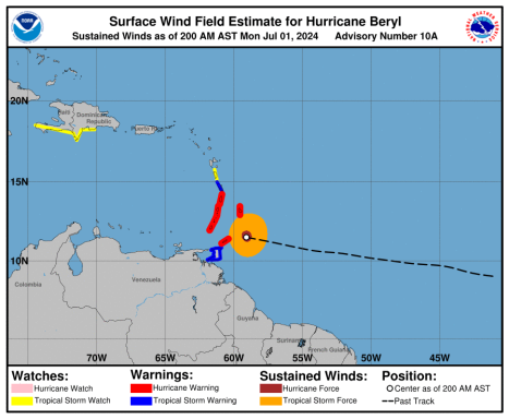
WATCHES AND WARNINGS -------------------- CHANGES WITH THIS ADVISORY: None.
SUMMARY OF WATCHES AND WARNINGS IN EFFECT:
A Hurricane Warning is in effect for...
* Barbados
* St. Lucia
* St. Vincent and the Grenadine Islands
* Grenada
* Tobago
A Tropical Storm Warning is in effect for...
* Martinique
* Trinidad A Tropical Storm Watch is in effect for...
* Dominica
* South coast of Dominican Republic from Punta Palenque westward to the border with Haiti
* South coast of Haiti from the border with the Dominican Republic to Anse d'Hainault
A Hurricane Warning means that hurricane conditions are expected somewhere within the warning area. Preparations to protect life and property should be rushed to completion.
A Tropical Storm Warning means that tropical storm conditions are expected somewhere within the warning area within 36 hours.
A Tropical Storm Watch means that tropical storm conditions are possible within the watch area, generally within 48 hours. Interests elsewhere in the Lesser Antilles, Hispaniola, Jamaica, the Cayman Islands, and the remainder of the northwestern Caribbean should closely monitor the progress of Beryl.
Additional watches or warnings may be required today. For storm information specific to your area, please monitor products issued by your national meteorological service.
DISCUSSION AND OUTLOOK ----------------------
At 200 AM AST (0600 UTC), the eye of Hurricane Beryl was located near latitude 11.5 North, longitude 59.1 West. Beryl is moving toward the west near 20 mph (31 km/h). A continued quick westward to west-northwestward motion is expected during the next few days. On the forecast track, the center of Beryl is expected to move across the Windward Islands this morning and across the southeastern and central Caribbean Sea late today through Wednesday.
Maximum sustained winds are near 120 mph (195 km/h) with higher gusts. Beryl is a category 3 hurricane on the Saffir-Simpson Hurricane Wind Scale. Fluctuations in strength are likely during the next day or so, but Beryl is expected to remain a dangerous major hurricane as its core moves through the Windward Islands into the eastern Caribbean.
Hurricane-force winds extend outward up to 30 miles (45 km) from the center and tropical-storm-force winds extend outward up to 115 miles (185 km). Grantley Adams International Airport on Barbados recently reported a wind gust to 45 mph (72 km/h). The minimum central pressure based on Hurricane Hunter aircraft data is 965 mb (28.50 inches).
HAZARDS AFFECTING LAND ----------------------
Key messages for Beryl can be found in the Tropical Cyclone Discussion under AWIPS header MIATCDAT2 and WMO header WTNT42 KNHC.
WIND:
Hurricane conditions are expected in the hurricane warning area beginning early this morning. Potentially catastrophic wind damage is expected where the core of Beryl moves through portions of the Windward Islands, with the highest risk of the core in St. Vincent and the Grenadines, and Grenada. Wind speeds atop and on the windward sides of hills and mountains are often up to 30 percent stronger than the near-surface winds indicated in this advisory, and in some elevated locations could be even greater. Tropical storm conditions are expected in the tropical storm warning area starting soon, making outside preparations difficult or dangerous. Tropical storm conditions are possible within the watch area starting this morning for Dominica, and by Tuesday afternoon for parts of the southern coast of Hispaniola.
STORM SURGE:
A life-threatening storm surge will raise water levels by as much as 6 to 9 feet above normal tide levels in areas of onshore winds near where the eye makes landfall in the hurricane warning area. Near the coast, the surge will be accompanied by large and destructive waves.
RAINFALL:
Hurricane Beryl is expected to produce rainfall totals of 3 to 6 inches across Barbados and the Windward Islands through today. Localized maxima of 10 inches is possible, especially in the Grenadines. This rainfall may cause flash flooding in vulnerable areas. For a complete depiction of forecast rainfall and flash flooding associated with Hurricane Beryl, please see the National Weather Service Storm Total Rainfall Graphic, available at hurricanes.gov/graphics_at2.shtml?rainqpf SURF:
Large swells generated by Beryl are expected across Windward and southern Leeward Islands during the next couple of days. Swells are also expected to reach the southern coasts of Puerto Rico and Hispaniola in the next day or so. These swells are expected to cause life-threatening surf and rip current conditions.
Please consult products from your local weather office.
NEXT ADVISORY ------------- Next complete advisory at 500 AM AST. $$ Forecaster Blake"
---------------------------------------------------------------------------------------------------------------------------------------------------------------------------------------------
<<<<......PAST ADVISTORIES.....>>>>
The 5pm advisory: According to the National Hurricane Center, Major Hurricane Beryl is 200 miles S.E. of Barbados and 260 miles S.S.E of St. Vincent and is traveling at 10 MPH to the N.W. with wind speeds up to 130 MPH and a pressure gradient of 958 MB.
WATCHES AND WARNINGS --------------------
CHANGES WITH THIS ADVISORY:
The government of the Trinidad and Tobago has issued a Tropical Storm Warning for the island of Trinidad.
SUMMARY OF WATCHES AND WARNINGS IN EFFECT:
A Hurricane Warning is in effect for...
* Barbados
* St. Lucia
* St. Vincent and the Grenadine Islands
* Grenada
* Tobago
A Tropical Storm Warning is in effect for...
* Martinique
* Trinidad
A Tropical Storm Watch is in effect for...
* Dominica
* South coast of Dominican Republic from Punta Palenque westward to the border with Haiti
* South coast of Haiti from the border with the Dominican Republic to Anse d'Hainault
A Hurricane Warning means that hurricane conditions are expected somewhere within the warning area. Preparations to protect life and property should be rushed to completion.
A Tropical Storm Warning means that tropical storm conditions are expected somewhere within the warning area within 36 hours.
A Tropical Storm Watch means that tropical storm conditions are possible within the watch area, generally within 48 hours. Interests elsewhere in the Lesser Antilles, Hispaniola, Jamaica, the Cayman Islands, and the remainder of the northwestern Caribbean should closely monitor the progress of Beryl.
Additional watches or warnings may be required tonight or on Monday. For storm information specific to your area, please monitor products issued by your national meteorological service.
DISCUSSION AND OUTLOOK ----------------------
At 800 PM AST (0000 UTC), the center of Hurricane Beryl was located near latitude 11.2 North, longitude 57.3 West. Beryl is moving toward the west-northwest near 18 mph (30 km/h). A continued quick westward to west-northwestward motion is expected during the next few days. On the forecast track, the center of Beryl is expected to move across the Windward Islands Monday morning and across the southeastern and central Caribbean Sea late Monday through Wednesday. Data from both the Air Force Reserve and NOAA Hurricane Hunter aircraft indicate that maximum sustained winds remain near 130 mph (215 km/h) with higher gusts. Beryl is a category 4 hurricane on the Saffir-Simpson Hurricane Wind Scale. Fluctuations in strength are likely during the next day or so, and Beryl is expected to remain an extremely dangerous category 4 hurricane through landfall in the Windward Islands. Hurricane-force winds extend outward up to 30 miles (45 km) from the center and tropical-storm-force winds extend outward up to 115 miles (185 km). The minimum central pressure based on Hurricane Hunter aircraft data is 958 mb (28.29 inches).
HAZARDS AFFECTING LAND ----------------------
Key messages for Beryl can be found in the Tropical Cyclone Discussion under AWIPS header MIATCDAT2 and WMO header WTNT42 KNHC.
WIND: Hurricane conditions are expected in the hurricane warning area beginning early Monday morning. Potentially catastrophic wind damage is expected where the eyewall or core of Beryl moves through portions of the Windward Islands, with the highest risk of the core in St. Vincent and the Grenadines, and Grenada. Wind speeds atop and on the windward sides of hills and mountains are often up to 30 percent stronger than the near-surface winds indicated in this advisory, and in some elevated locations could be even greater. Tropical storm conditions are expected in the tropical storm warning area starting late tonight, making outside preparations difficult or dangerous. Tropical storm conditions are possible within the watch area starting late tonight for Dominica, and by Tuesday afternoon for parts of the southern coast of Hispaniola.
STORM SURGE: A life-threatening storm surge will raise water levels by as much as 6 to 9 feet above normal tide levels in areas of onshore winds near where the eye makes landfall in the hurricane warning area. Near the coast, the surge will be accompanied by large and destructive waves.
RAINFALL: Hurricane Beryl is expected to produce rainfall totals of 3 to 6 inches across Barbados and the Windward Islands through Monday. Localized maxima of 10 inches is possible, especially in the Grenadines. This rainfall may cause flash flooding in vulnerable areas. For a complete depiction of forecast rainfall and flash flooding associated with Hurricane Beryl, please see the National Weather Service Storm Total Rainfall Graphic, available at hurricanes.gov/graphics_at2.shtml?rainqpf
SURF: Large swells generated by Beryl are expected across Windward and southern Leeward Islands during the next couple of days. Swells are also expected to reach the southern coasts of Puerto Rico and Hispaniola in the next day or so. These swells are expected to cause life-threatening surf and rip current conditions. Please consult products from your local weather office.
©Copyright 2024. All rights reserved. The Blake Moia Show. Privacy Policy
We need your consent to load the translations
We use a third-party service to translate the website content that may collect data about your activity. Please review the details in the privacy policy and accept the service to view the translations.
